Alberni Valley Activities & Recreation
Connected to Fun, Every Day of the Year
It’s rare to find a space as connected to adventure as the Alberni Valley. Tee off before the rest of the country is done shovelling their drive; reel in a King in Port Alberni, the Ultimate Fishing Town; race across the Alberni Inlet on your kite board with the wind at your back; go for a world-class dive to explore the rich and diverse marine ecology; or hang out with the family around the campfire, telling stories, taking moments, and making memories. Our warm, dry climate makes for an exceptional getaway, every day. You will find these Alberni Valley activities & recreation will have something for everyone at every age and every level.
Alberni Valley Activities & Recreation
Fishing
The Alberni Valley is known as the Salmon Capital of the World, and Port Alberni was crowned the Ultimate Fishing Town by the World Fishing Network in 2010. Charter companies will take you on the waters of the Alberni Inlet or Barkley Sound to fish for sockeye, coho, and the big kings – Chinook salmon. Freshwater fans will find plenty of Cutthroat and rainbow trout in Sproat Lake, Loon Lake, and Taylor Arm.
The chinook run in the Alberni Inlet is looking very promising, with predictions that the Chinook numbers will stay strong for the foreseeable future. This is great news for anglers looking to catch their limit, as the waters around Port Alberni are not subject to the conservation limits put in place to protect the stock from the Fraser River. Saltwater or fresh, the rewards for angling in the Alberni Valley are delicious. Check out the annual Salmon Festival every Labor Day Weekend for a fun family event.
Rebecca Bollwit, Zenseekers
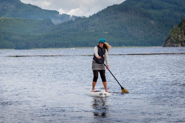
Stand Up Paddleboarding
The Alberni Valley has some of the best paddling in the world. Cameron Lake, Sproat Lake, and Great Central Lake offer beautiful surroundings and areas with minimal motorized water traffic, and the Alberni Inlet has over 40 kilometres of sheltered, flat water ocean-paddling potential, typically with low winds in the morning.
Golf
The Alberni Valley has a great range of golf experiences, from the Par 70 18-hole course at the Alberni Golf Club, to the nine-hole executive course at The Hollies, and for something different, try the nine-hole disc golf course at Echo Centre.
Hiking Trails
From breath-taking views to sweeping cascades, hiking in the Alberni Valley is not only an amazing way to spend time outdoors, it’s also very accessible. With over 100 hiking trails, many of which are rated at an easy to moderate skill level, you will be sure to find one to match your skill level and interest. Learn more about some of our favorite hiking trails in the Alberni Valley.
Mountain Biking
The Alberni Valley has three distinct sets of mountain biking trails: City Trails in Port Alberni (12 trails); Coombs Candy, northeast of Port Alberni (37 trails); and the Sproat Lake system (12 trails). Practice your jumps and build your skills at the Cougar Smith Bike Skills Park in Port Alberni. Not sure where to start? Check out our post on some of our favourite trails.
Kayaking
Some of the best kayaking on the west coast of Vancouver Island is waiting for you in the Alberni Valley. The Alberni Inlet has over 40 kilometres of flat-water ocean paddling, and the Broken Group Islands in Barkley Sound offer over 100 islands to paddle around and explore.
Swimming
Sproat Lake and Cameron Lake are popular freshwater swimming spots during the summer. Canal Beach offers a sheltered area for the saltwater dip. For indoor swimming year-round, go to the Echo Aquatic and Fitness Centre in Port Alberni.
River Tubing
River tubing the Stamp River below Stamp Falls and above the Paper Mill Dam is a popular summer activity. Tubing is a central part of Vancouver Island summer culture, and can be enjoyed safely with caution — river currents and conditions may vary and may be unsuitable for tubing or swimming at times. Respect the water and enjoy the experience!
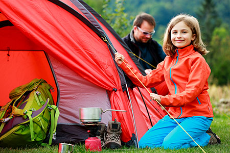
Camping
There are lots of options for camping in the Alberni Valley, including family-friendly provincial park campgrounds, off-beat hike-in wilderness camping, and full-service RV parks where you can start relaxing minutes after you arrive. Check out our list of campgrounds in and near Port Alberni, giving you a Vancouver Island experience.
Picnics and Parks
When looking for an easy day outdoors, visit one of our many parks. Just pack a picnic lunch and a blanket for a relaxing day with nature. Amenities will vary, some parks offer picnic areas with tables and restrooms, swimming, wildlife viewing or cultural landmarks. Go for a walk, throw a frisbee, or kick back and read a book.
Surfing
Stop in Port Alberni to grab everything you need to enjoy a day of surfing on the far west coast. Local outfitters have board rentals, wet suits, and the best surf apparel.
Scuba Diving
Barkley Sound was one of Jacques Cousteau’s top five dive spots in the world. The rich diversity of fish and marine ecology combined with a mild climate; good, year-round diving conditions; and an abundance of dive sites make this a premier destination for divers.
Waterskiing and Wakeboarding
If you want to rip up the water on a wakeboard or water skis, Sproat Lake is the place to go. Local guides and outfitters have everything you need to enjoy your time on the water, and if you bring your own setup, you can find launch information here.
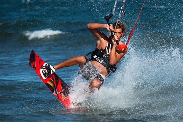
Windsurfing and Kiteboarding
The Alberni Valley is quickly becoming known as a paradise for wind riders. While the weather can get cold and damp in Tofino and Long Beach, the temperature in Port Alberni is typically much drier and warmer. These unique weather conditions cause predictable afternoon winds, especially in the summertime, blowing up the Alberni Inlet, resulting in some of the best conditions for kitesurfing and windsurfing on the West Coast of Vancouver Island.
Kite surfers can be seen catching big air off the launch by the Maritime Discovery Centre lighthouse, and racing up and down the Alberni Inlet in front of Harbour Quay. Canal Beach is another popular place for kiteboarding and windsurfing.